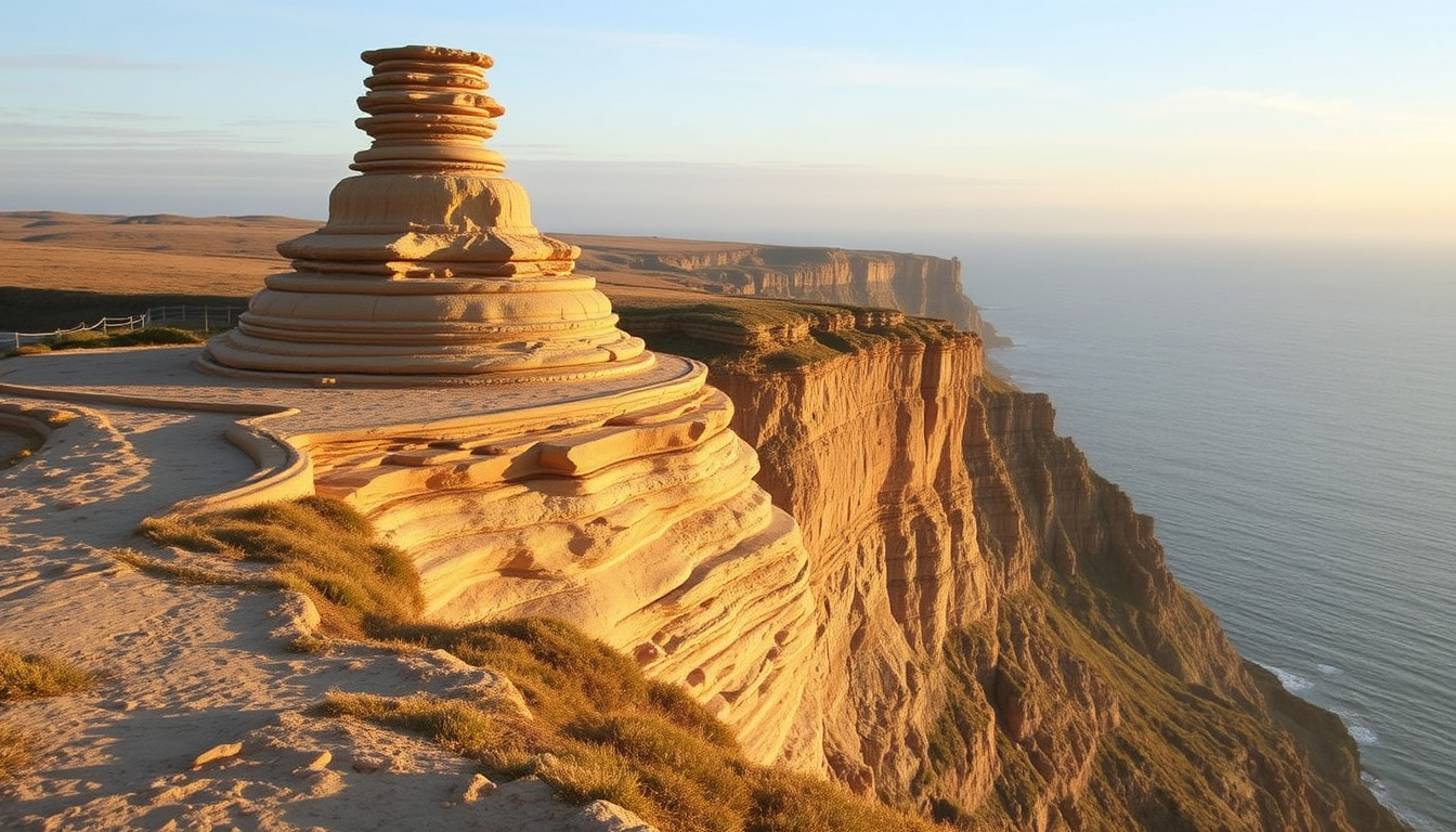
Wedding Cake Rock stands as one of the most distinctive geological formations along Sydney’s coastal hiking trails, drawing visitors with its striking white sandstone appearance against the dramatic cliff edges of Royal National Park. The formation, named for its layered resemblance to a wedding cake, has become a popular destination for bushwalkers seeking breathtaking coastal views. However, the site carries significant safety concerns due to ongoing erosion of the surrounding sandstone cliffs, prompting authorities to implement protective fencing and warning systems for all visitors.
Located approximately one hour’s drive south of Sydney, the rock formation sits along the renowned Coast Track, a multi-day hiking route that spans roughly 26 kilometres through diverse coastal landscapes. The walk to Wedding Cake Rock typically begins from the village of Bundeena, offering hikers a moderate trek through bushland before emerging at spectacular ocean viewpoints. Understanding the access routes, current conditions, and safety protocols is essential for anyone planning a visit to this remarkable but potentially hazardous landmark.
Wedding Cake Rock Walk: Complete Access Guide
The journey to Wedding Cake Rock begins at the end of Beachcomber Avenue in Bundeena, where a car park provides the main trailhead for hikers. From this point, the track follows a fire trail for approximately 200 metres before hikers must take the second left turn onto a well-signed walking path. The route features directional posts and arrows throughout, making navigation relatively straightforward even for less experienced bushwalkers. The path meanders along the cliff edge, offering panoramic views of the coastline before eventually revealing the distinctive white formation that has made this location famous.
The track forms part of the larger Coast Track, an approximately 26-kilometre route that requires two full days to complete for through-hikers. However, day visitors typically focus on the section between Bundeena and Wedding Cake Rock, which represents the most accessible portion of this coastal walk. The terrain remains moderately trafficked throughout the year, though early mornings and late afternoons generally offer a quieter experience with better opportunities for photography and contemplation of the landscape.
The walk from Bundeena to Wedding Cake Rock takes most visitors between 30 and 40 minutes in one direction, though estimates vary depending on fitness levels and trail conditions. The return journey covers approximately 8.6 kilometres and generally requires around 2 hours and 47 minutes of total walking time.
Royal National Park, Sydney NSW
Coast Track from Bundeena, 5.7km moderate hike
Fragile formation, fenced with warning signs
Early morning or late afternoon, check weather first
Key Facts for Planning Your Visit
- The formation sits on the cliff edge and consists of pure white sandstone that contrasts sharply with the darker rock surrounding it
- Wedding Cake Rock is now fenced off with warning signs due to ongoing erosion concerns
- Public transport options include taking the train to Cronulla, then the ferry to Bundeena
- Park entry fees apply when parking within Royal National Park boundaries
- The site has no wheelchair accessibility due to the nature of the walking track
- Mobile phone reception along the track is limited, making emergency communication challenging
Quick Reference: Walk Statistics
| Statistic | Details |
|---|---|
| Distance from car park | 5.7 kilometres |
| Return trip distance | Approximately 8.6 kilometres |
| One-way walking time | 30 to 40 minutes (up to 1.5 hours depending on fitness) |
| Total return duration | Approximately 2 hours 47 minutes |
| Difficulty rating | Moderate |
| Elevation gain | Approximately 826 feet |
Understanding the Safety Concerns at Wedding Cake Rock
The striking white sandstone formation that makes Wedding Cake Rock so visually appealing is also the source of significant safety concerns. The pure white sandstone composing the formation is particularly susceptible to erosion from wind, rain, and salt spray, weakening its structural integrity over time. Unlike the more stable darker sandstone formations in the surrounding park, this lighter-coloured rock lacks the density and cohesion that characterize safer cliff edges throughout the region.
Park authorities have installed fencing around the immediate vicinity of Wedding Cake Rock, complete with warning signs advising visitors to maintain a safe distance. Despite these precautions, documented cases exist of visitors climbing over the barriers to position themselves closer to the formation for photographs. This behaviour poses considerable risk, as the weakened sandstone can give way without warning, potentially sending individuals sliding down the unstable cliff face toward the rocks and ocean below.
NSW National Parks advises that Wedding Cake Rock is fenced off due to the fragile nature of the formation. Visitors who ignore warning signs and climb barriers do so at considerable personal risk. The track may be closed during total fire ban days, and visitors should always check for current alerts and closures before planning their journey.
Essential Safety Recommendations
- Wear appropriate footwear with good grip, suitable for uneven coastal terrain
- Carry sufficient food and drinking water for the entire return journey
- Use toilet facilities at the Bundeena end before starting the walk
- Bring a charged mobile phone, though reception remains limited along the track
- In emergencies, dial 000 for emergency services despite coverage limitations
- Avoid walking back in darkness without a torch, as the uneven terrain creates tripping hazards
Location and Geographic Context
Wedding Cake Rock occupies a dramatic position along the Illawarra coastline within the boundaries of Royal National Park, Australia’s oldest national park established in 1879. The park stretches along the coastal region approximately one hour’s drive south of Sydney’s central business district, encompassing diverse ecosystems including heathland, woodland, and coastal cliff environments. The formation sits roughly one hour’s walk south of the village of Bundeena, which serves as the primary access point for visitors approaching from the northern side of the track.
The coastal landscape surrounding Wedding Cake Rock exemplifies the geological processes that have shaped this region over millions of years. The white sandstone formation originated from accumulated sand deposits during the Triassic period, later compressed and exposed through tectonic uplift and erosion. The distinctive layering visible in the formation resulted from varying sediment compositions deposited over geological timeframes, creating the banded appearance that resembles a tiered wedding cake.
For visitors travelling from Sydney, the journey to Royal National Park passes through suburban Sutherland Shire before entering the park boundaries. The park’s coastal section features numerous beaches, lookouts, and hiking opportunities, with Wedding Cake Rock representing one of the most photographed locations along the Coastal Track route. Alternative access points exist for those completing longer through-hikes, though the Bundeena route remains the most accessible option for day visitors.
Getting There: Transport Options
Visitors without private vehicles can access the trailhead via public transport by taking a train to Cronulla station, which sits approximately one hour from Sydney Town Hall. From Cronulla, a ferry service operates to Bundeena, with the journey taking roughly 25 minutes. Upon arriving at Bundeena wharf, visitors walk to the end of Beachcomber Avenue to reach the car park and trailhead. This public transport option makes Wedding Cake Rock accessible to international visitors and those preferring not to drive during their Sydney stay.
Current Conditions and Practical Planning
Planning a visit to Wedding Cake Rock requires consideration of several practical factors that can significantly impact the experience. Weather conditions along the exposed coastal cliffs can change rapidly, with afternoon sea breezes potentially making the return journey less comfortable than the outbound walk. Morning visits generally offer calmer conditions and better photography lighting, though the popularity of this time slot means encountering more fellow hikers on the trail.
The track surface varies between compacted earth and exposed rock sections, with some areas requiring careful navigation around tree roots and erosion channels. While the path maintains a moderate difficulty rating, the uneven surface makes proper footwear essential regardless of the season. During summer months, the coastal location provides some cooling effect, but sun protection remains important given the limited tree cover along certain sections of the route.
Before setting out, visitors should verify current track conditions and any temporary closures through the NSW National Parks website. This resource provides up-to-date alerts regarding fire bans, track maintenance, or safety-related closures that may affect access to Wedding Cake Rock.
What to Bring for the Hike
- At least one litre of water per person for the return journey
- Sun protection including sunscreen, hat, and sunglasses
- Sturdy closed-toe walking shoes or hiking boots
- A basic first aid kit for minor trail injuries
- A fully charged phone in case of emergency (accept limited coverage)
- Snacks or a packed lunch for the return journey
Wedding Cake Rock Timeline and Historical Context
Wedding Cake Rock has long captured the imagination of visitors to Royal National Park, though its precise geological formation history remains subject to ongoing scientific study. The formation developed over millions of years through natural sedimentary processes, with the distinctive white colouring resulting from the particular mineral composition and bleaching effects of exposure to sun and salt air. Unlike human-built structures with documented construction dates, geological formations emerge gradually through imperceptible processes that span geological timeframes.
The naming of the formation reflects its visual appearance, with the stacked white sandstone layers creating a resemblance to the traditional tiered wedding cake. This descriptive name has been in use for decades within the hiking community and local populations, though the exact origin of the terminology remains unclear. As photography technology improved and social media expanded, the formation’s distinctive appearance contributed to its growing popularity as a tourist destination throughout the 2000s and 2010s.
Royal National Park itself holds significant place in Australian conservation history as the world’s second-oldest national park, following Yellowstone in the United States. The establishment of the park in 1879 reflected growing recognition of the need to preserve natural landscapes for future generations. Within this protected area, formations like Wedding Cake Rock serve as natural landmarks that help visitors connect with the geological heritage of the region while providing educational opportunities to understand coastal erosion processes.
What We Know and What Remains Uncertain
Established Information
- Wedding Cake Rock consists of white sandstone located in Royal National Park
- The formation sits along the Coast Track approximately 5.7km from Bundeena
- The site is fenced with official warning signs in place
- The rock exhibits ongoing erosion due to natural weathering processes
- Park authorities recommend against climbing barriers or approaching too closely
- The track is closed during total fire ban days
Areas of Uncertainty
- Specific details about historical rockfalls or collapses remain limited in public records
- The precise rate of ongoing erosion has not been publicly quantified by authorities
- Detailed personal incident reports are not publicly available
- Future stability predictions require specialist geological assessment
- Exact timing of when safety barriers were installed is not widely documented
- Current weather patterns and their specific impact on the formation require local monitoring
Visitor Guidelines and Official Recommendations
The New South Wales National Parks and Wildlife Service maintains the official position that Wedding Cake Rock represents a fragile geological feature requiring careful management to ensure visitor safety. The fencing and signage installed around the formation reflect this cautious approach, prioritizing visitor protection over unrestricted access to the immediate formation area. Visitors are encouraged to enjoy views of the formation from the established viewing areas rather than attempting to approach the unstable cliff edge.
“Wedding Cake Rock is a fragile formation and is fenced off with warning signs. Visitors should follow all safety advice and stay behind the barriers for their own protection.”
— NSW National Parks and Wildlife Service
Beyond the immediate formation area, the surrounding Coastal Track offers numerous other attractions for visitors to explore. The multi-day route passes through diverse coastal landscapes, including secluded beaches, dramatic headlands, and opportunities to observe native wildlife in their natural habitat. For those with more time available, continuing beyond Wedding Cake Rock to other landmarks along the track provides a more comprehensive experience of this remarkable coastal environment.
Summary: Planning Your Visit to Wedding Cake Rock
Wedding Cake Rock remains one of the most recognizable geological features within Royal National Park, offering visitors a memorable hiking destination approximately one hour from Sydney. The walk from Bundeena provides a moderate challenge suitable for most fitness levels, with well-marked trails and directional signage ensuring relatively straightforward navigation. However, the formation itself demands respect and appropriate caution, with official barriers and warning signs indicating the genuine risks posed by ongoing erosion of the unstable white sandstone.
Visitors should prioritize safety by remaining behind established barriers, wearing appropriate footwear, carrying sufficient water, and checking current conditions before departing. The combination of dramatic coastal scenery and unique geological features makes Wedding Cake Rock a worthwhile destination, provided visitors approach the site with appropriate awareness of its fragile nature. For those seeking additional information about planning visits to Australian coastal attractions, resources covering destinations like Sea World Gold Coast provide useful context for exploring the broader region.
Frequently Asked Questions
How far is the walk to Wedding Cake Rock?
The walk from the Bundeena car park to Wedding Cake Rock covers approximately 5.7 kilometres one way, making the return journey roughly 8.6 kilometres. Most visitors require 30 to 40 minutes for the one-way trip, with the full return taking around 2 hours and 47 minutes depending on fitness levels and how often visitors pause to enjoy the views.
Is it safe to visit Wedding Cake Rock?
Wedding Cake Rock is fenced off due to the fragile nature of the formation and ongoing erosion concerns. While the general walking track remains open, visitors should respect barrier restrictions, stay behind fences, and avoid approaching the unstable cliff edge. Following official safety guidance significantly reduces the inherent risks of visiting this coastal formation.
What is the best time of day to visit?
Early morning or late afternoon typically offers the best experience, with fewer crowds and more comfortable temperatures for hiking. Morning visits provide excellent photography lighting and calmer coastal conditions, though visitors should ensure they have enough daylight remaining for the return journey. Checking weather forecasts before departing remains essential regardless of planned timing.
Can I access Wedding Cake Rock by public transport?
Yes, visitors without vehicles can reach the trailhead via public transport. Take a train from Sydney to Cronulla, then the ferry across to Bundeena. The ferry journey takes approximately 25 minutes, after which it’s a short walk to the car park and trailhead at the end of Beachcomber Avenue.
Are there any facilities along the track?
Toilet facilities are available at the Bundeena end before starting the walk, but few amenities exist along the track itself. Visitors should use these facilities before departing and carry all necessary supplies including water, food, and sun protection. Mobile phone reception is limited throughout the hike, so visitors should plan accordingly.
What should I do if there’s an emergency on the track?
Mobile phone reception is limited along the track, but visitors should attempt to call 000 in genuine emergencies. Carrying a personal locator beacon is recommended for remote hikes. For non-emergency situations, remain calm, provide first aid if trained, and wait for other hikers to pass who may be able to summon help from areas with better phone reception.
Does Wedding Cake Rock have wheelchair access?
No, Wedding Cake Rock does not have wheelchair access. The walking track features uneven surfaces, exposed tree roots, and varies between compacted earth and rocky sections, making it unsuitable for wheelchair users. The formation itself sits behind barriers for safety reasons regardless of accessibility considerations.

Rachel Walsh leads fact-checking, source verification and corrections at Aussie Report.